Apple segmentation in 3D point clouds
This internship aimed at segmenting apples from a high-resolution Terrestrial Lidar Scan (TLS) Point Cloud with a simple clustering approach and a deep learn...
This internship aimed at segmenting apples from a high-resolution Terrestrial Lidar Scan (TLS) Point Cloud with a simple clustering approach and a deep learn...
Dense point clouds generated from Terrestrial Lidar Scanner pose a challenge to classification algorithm because of their large data amounts. Here a scanline...
Collection of full-waveform terrestrial LiDAR data poses unique challenges during data acquisition and generates data with useful extra attributes. The scann...
In the last two decades, Terrestrial Laser Scanning (TLS) has gained increasing importance as a ground-based remote sensing technique for measuring three-dim...
Convert your BBB recordings to a compressed MP4 stream with webcam overlay and logo.
Can you use your Samsung Galaxy or iPad as an input device / whiteboard for online teaching?
This short entry describes a comparison of KDTree implementations for Lidar PointClouds (PC) and Structure-from-Motion (SfM) dataset.
This internship aimed at segmenting apples from a high-resolution Terrestrial Lidar Scan (TLS) Point Cloud with a simple clustering approach and a deep learn...
Introduction Sediment charateristics and grain-size distribution carries important information on the drainage system, the ecosystem, and the weather conditi...
Dense point clouds generated from Terrestrial Lidar Scanner pose a challenge to classification algorithm because of their large data amounts. Here a scanline...
South America is characterized by steep gradients in tectonism, topography, and climate. In this blog entry, we show how these gradients can be visualized do...
Using GMT to merge topographic and wind-vector data for visually-appealing maps.
An Earthquake occurred in NW Argentina on Nov-30, 2020.
South America is characterized by steep gradients in tectonism, topography, and climate. In this blog entry, we show how these gradients can be visualized do...
First results from processing interferograms from SAOCOM - an Argentinean L-band SAR satellite - and ISCE.
An Earthquake occurred in NW Argentina on Nov-30, 2020.
Can you use your Samsung Galaxy or iPad as an input device / whiteboard for online teaching?
This short entry describes a comparison of KDTree implementations for Lidar PointClouds (PC) and Structure-from-Motion (SfM) dataset.
Can you use your Samsung Galaxy or iPad as an input device / whiteboard for online teaching?
This short entry describes a comparison of KDTree implementations for Lidar PointClouds (PC) and Structure-from-Motion (SfM) dataset.
Can you use your Samsung Galaxy or iPad as an input device / whiteboard for online teaching?
This short entry describes a comparison of KDTree implementations for Lidar PointClouds (PC) and Structure-from-Motion (SfM) dataset.
Can you use your Samsung Galaxy or iPad as an input device / whiteboard for online teaching?
This short entry describes a comparison of KDTree implementations for Lidar PointClouds (PC) and Structure-from-Motion (SfM) dataset.
Can you use your Samsung Galaxy or iPad as an input device / whiteboard for online teaching?
This short entry describes a comparison of KDTree implementations for Lidar PointClouds (PC) and Structure-from-Motion (SfM) dataset.
Can you use your Samsung Galaxy or iPad as an input device / whiteboard for online teaching?
This short entry describes a comparison of KDTree implementations for Lidar PointClouds (PC) and Structure-from-Motion (SfM) dataset.
Can you use your Samsung Galaxy or iPad as an input device / whiteboard for online teaching?
This short entry describes a comparison of KDTree implementations for Lidar PointClouds (PC) and Structure-from-Motion (SfM) dataset.
Introduction Sediment charateristics and grain-size distribution carries important information on the drainage system, the ecosystem, and the weather conditi...
Fine individiual tree crown delineation can be achieved from RGB + NIR orthophotos using CNN-based semantic segmentation with weighted losses, but how do dif...
Dense point clouds generated from Terrestrial Lidar Scanner pose a challenge to classification algorithm because of their large data amounts. Here a scanline...
In the last two decades, Terrestrial Laser Scanning (TLS) has gained increasing importance as a ground-based remote sensing technique for measuring three-dim...
On January 9th, 2023, a catastrophic landslide severely impacted the upper basin of Chontaduro Creek, located in the municipality of Rosas-Cauca in southwest...
In the last two decades, Terrestrial Laser Scanning (TLS) has gained increasing importance as a ground-based remote sensing technique for measuring three-dim...
This internship aimed at segmenting apples from a high-resolution Terrestrial Lidar Scan (TLS) Point Cloud with a simple clustering approach and a deep learn...
Collection of full-waveform terrestrial LiDAR data poses unique challenges during data acquisition and generates data with useful extra attributes. The scann...
Workshop organized and led by Dr Taylor Smith (University of Potsdam, Germany), Dr Bodo Bookhagen (University of Potsdam, Germany) and Dr Shakil Regmi (South...
Workshop organized and led by Dr Taylor Smith (University of Potsdam, Germany), Dr Bodo Bookhagen (University of Potsdam, Germany) and Dr Shakil Regmi (South...
Workshop organized and led by Dr Taylor Smith (University of Potsdam, Germany), Dr Bodo Bookhagen (University of Potsdam, Germany) and Dr Shakil Regmi (South...
Workshop organized and led by Dr Taylor Smith (University of Potsdam, Germany), Dr Bodo Bookhagen (University of Potsdam, Germany) and Dr Shakil Regmi (South...
Workshop organized and led by Dr Taylor Smith (University of Potsdam, Germany), Dr Bodo Bookhagen (University of Potsdam, Germany) and Dr Shakil Regmi (South...
Workshop organized and led by Dr Taylor Smith (University of Potsdam, Germany), Dr Bodo Bookhagen (University of Potsdam, Germany) and Dr Shakil Regmi (South...
Photogrammetric models are widely used in geoscience, but subtle processing errors can significantly distort their geometry. This study investigates the caus...
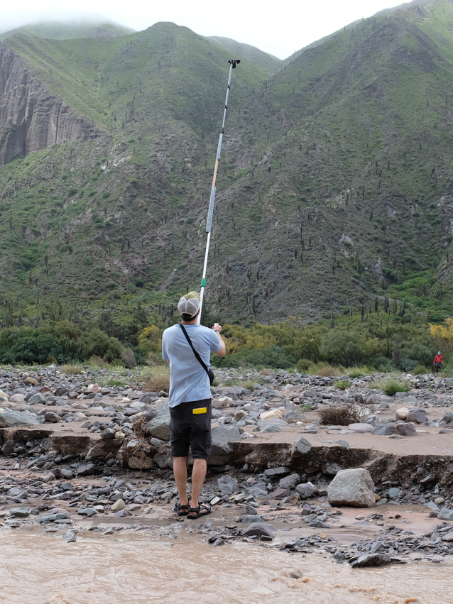
Precise Camera Calibration is an important part of generating high-quality points clouds and mesh models. We outline some basic procedures to generate reliab...
Using GMT to merge topographic and wind-vector data for visually-appealing maps.
Using GMT to merge topographic and wind-vector data for visually-appealing maps.
Using GMT to merge topographic and wind-vector data for visually-appealing maps.
Using GMT to merge topographic and wind-vector data for visually-appealing maps.
South America is characterized by steep gradients in tectonism, topography, and climate. In this blog entry, we show how these gradients can be visualized do...
South America is characterized by steep gradients in tectonism, topography, and climate. In this blog entry, we show how these gradients can be visualized do...
South America is characterized by steep gradients in tectonism, topography, and climate. In this blog entry, we show how these gradients can be visualized do...
South America is characterized by steep gradients in tectonism, topography, and climate. In this blog entry, we show how these gradients can be visualized do...
An Earthquake occurred in NW Argentina on Nov-30, 2020.
An Earthquake occurred in NW Argentina on Nov-30, 2020.
Convert your BBB recordings to a compressed MP4 stream with webcam overlay and logo.
Convert your BBB recordings to a compressed MP4 stream with webcam overlay and logo.
Convert your BBB recordings to a compressed MP4 stream with webcam overlay and logo.
First results from processing interferograms from SAOCOM - an Argentinean L-band SAR satellite - and ISCE.
First results from processing interferograms from SAOCOM - an Argentinean L-band SAR satellite - and ISCE.
First results from processing interferograms from SAOCOM - an Argentinean L-band SAR satellite - and ISCE.
First results from processing interferograms from SAOCOM - an Argentinean L-band SAR satellite - and ISCE.
First results from processing interferograms from SAOCOM - an Argentinean L-band SAR satellite - and ISCE.
First results from processing interferograms from SAOCOM - an Argentinean L-band SAR satellite - and ISCE.
Road traffic reduction during the spring 2020 lockdown caused significant NO2 decrease.
Road traffic reduction during the spring 2020 lockdown caused significant NO2 decrease.
Road traffic reduction during the spring 2020 lockdown caused significant NO2 decrease.
Road traffic reduction during the spring 2020 lockdown caused significant NO2 decrease.
Road traffic reduction during the spring 2020 lockdown caused significant NO2 decrease.
Neighboring terrain facing in different directions is not equally steep. This effect is caused by the complex interactions of geology, tectonics, vegetation,...
Neighboring terrain facing in different directions is not equally steep. This effect is caused by the complex interactions of geology, tectonics, vegetation,...
Neighboring terrain facing in different directions is not equally steep. This effect is caused by the complex interactions of geology, tectonics, vegetation,...
Neighboring terrain facing in different directions is not equally steep. This effect is caused by the complex interactions of geology, tectonics, vegetation,...
Changes in global Total Water Storage (TWS) can be measured with satellites sensitive to gravity acceleration using the Gravity Recovery and Climate Experime...
Changes in global Total Water Storage (TWS) can be measured with satellites sensitive to gravity acceleration using the Gravity Recovery and Climate Experime...
Changes in global Total Water Storage (TWS) can be measured with satellites sensitive to gravity acceleration using the Gravity Recovery and Climate Experime...
Changes in global Total Water Storage (TWS) can be measured with satellites sensitive to gravity acceleration using the Gravity Recovery and Climate Experime...
The ICESat-2 mission provides new potential to observe geomorphic processes with a step size of 70 cm. Here is an application of a custom filtering approach ...
The ICESat-2 mission provides new potential to observe geomorphic processes with a step size of 70 cm. Here is an application of a custom filtering approach ...
The ICESat-2 mission provides new potential to observe geomorphic processes with a step size of 70 cm. Here is an application of a custom filtering approach ...
The ICESat-2 mission provides new potential to observe geomorphic processes with a step size of 70 cm. Here is an application of a custom filtering approach ...
The ICESat-2 mission provides new potential to observe geomorphic processes with a step size of 70 cm. Here is an application of a custom filtering approach ...
Fine individiual tree crown delineation can be achieved from RGB + NIR orthophotos using CNN-based semantic segmentation with weighted losses, but how do dif...
Fine individiual tree crown delineation can be achieved from RGB + NIR orthophotos using CNN-based semantic segmentation with weighted losses, but how do dif...
Fine individiual tree crown delineation can be achieved from RGB + NIR orthophotos using CNN-based semantic segmentation with weighted losses, but how do dif...
Fine individiual tree crown delineation can be achieved from RGB + NIR orthophotos using CNN-based semantic segmentation with weighted losses, but how do dif...
Conda environments provide an easy way to install relevant packages for a python environment. Here, we present a ‘Spatial Data Analysis’ (SDA) environment th...
Conda environments provide an easy way to install relevant packages for a python environment. Here, we present a ‘Spatial Data Analysis’ (SDA) environment th...
In the last two decades, Terrestrial Laser Scanning (TLS) has gained increasing importance as a ground-based remote sensing technique for measuring three-dim...
Dense point clouds generated from Terrestrial Lidar Scanner pose a challenge to classification algorithm because of their large data amounts. Here a scanline...
Dense point clouds generated from Terrestrial Lidar Scanner pose a challenge to classification algorithm because of their large data amounts. Here a scanline...
Dense point clouds generated from Terrestrial Lidar Scanner pose a challenge to classification algorithm because of their large data amounts. Here a scanline...
Regional-scale Earth surface process analyses require cost-effective, large-area coverage, high-resolution digital elevation models (DEMs). Stereogrammetry, ...
Regional-scale Earth surface process analyses require cost-effective, large-area coverage, high-resolution digital elevation models (DEMs). Stereogrammetry, ...
Regional-scale Earth surface process analyses require cost-effective, large-area coverage, high-resolution digital elevation models (DEMs). Stereogrammetry, ...
Regional-scale Earth surface process analyses require cost-effective, large-area coverage, high-resolution digital elevation models (DEMs). Stereogrammetry, ...
Regional-scale Earth surface process analyses require cost-effective, large-area coverage, high-resolution digital elevation models (DEMs). Stereogrammetry, ...
On January 9th, 2023, a catastrophic landslide severely impacted the upper basin of Chontaduro Creek, located in the municipality of Rosas-Cauca in southwest...
On January 9th, 2023, a catastrophic landslide severely impacted the upper basin of Chontaduro Creek, located in the municipality of Rosas-Cauca in southwest...
On January 9th, 2023, a catastrophic landslide severely impacted the upper basin of Chontaduro Creek, located in the municipality of Rosas-Cauca in southwest...
Introduction Sediment charateristics and grain-size distribution carries important information on the drainage system, the ecosystem, and the weather conditi...
Introduction Sediment charateristics and grain-size distribution carries important information on the drainage system, the ecosystem, and the weather conditi...
Precise Camera Calibration is an important part of generating high-quality points clouds and mesh models. We outline some basic procedures to generate reliab...
Precise Camera Calibration is an important part of generating high-quality points clouds and mesh models. We outline some basic procedures to generate reliab...
Precise Camera Calibration is an important part of generating high-quality points clouds and mesh models. We outline some basic procedures to generate reliab...
Precise Camera Calibration is an important part of generating high-quality points clouds and mesh models. We outline some basic procedures to generate reliab...
Precise Camera Calibration is an important part of generating high-quality points clouds and mesh models. We outline some basic procedures to generate reliab...
Tiling window managers create efficient, distraction-free workspaces that are particularly well-suited for coding, writing, and scientific research. Unlike t...
Tiling window managers create efficient, distraction-free workspaces that are particularly well-suited for coding, writing, and scientific research. Unlike t...
Tiling window managers create efficient, distraction-free workspaces that are particularly well-suited for coding, writing, and scientific research. Unlike t...
Tiling window managers create efficient, distraction-free workspaces that are particularly well-suited for coding, writing, and scientific research. Unlike t...
Photogrammetric models are widely used in geoscience, but subtle processing errors can significantly distort their geometry. This study investigates the caus...
Photogrammetric models are widely used in geoscience, but subtle processing errors can significantly distort their geometry. This study investigates the caus...
Photogrammetric models are widely used in geoscience, but subtle processing errors can significantly distort their geometry. This study investigates the caus...